I received an email tonight from an old friend, both chronologically, and in age. He, “Muleskinner”, and his wife, “Woodrose” are off hiking a large section of the Appalachian Trail this year. They both belong to our ATC hiking club here in Sarasota, Florida and bring to light the fact that not all of the retirees are sitting watching Gunsmoke re-runs. I thought I would post what he wrote, verbatim, I think it really captures the sense of how it feels to be out in the woods for a long time. Enjoy:
“From the EASTERN RITE of PASSAGE, April, 2015, Walking with spring.

My wife Eva (Woodrose) and I (Muleskinner) walked from Georgia to Maine on the Appalachian Trail (AT) in 183 days in 2005 – a life altering experience. Since then, we have walked thousands more miles together with packs on our backs, the majority of those miles on hiking trails out west. This spring, celebrating Eva’s retirement, we decided to return to the AT in Virginia, where lies more than a quarter of the 2,180 miles of the AT, to experience the southern Appalachian hardwood forest in its bare winter majesty; oaks, ash, hickory, cherry, poplar, leafless, branches bared to winter. Planning to hike the month of April from Damascus, Va. north, we arrived by pickup truck toward the end of March and decided to check out a couple of resupply locations along the Trail north of Damascus. Our first night, along side the AT just north of Bland, Va., we slept in the back of the truck, it seemed bitterly cold. We retreated back down to Bland, had coffee at the local DQ, whose manager told us it was 16 degrees at his house nearby this morning.We had extra quilts in the pickup, and with our dog Tyler sleeping between us, we were warm enough, but we were not really prepared for 16 degree nights; my bag rated for 20 degrees, and Woodrose always cold, even in her 5 degree WM bag.
We drove SW to Bristol, where we cached the pickup with friends who delivered us to the AT in Damascus, and hiked up the set of stairs that rose above the Creeper Trail (a famous local rail trail) the morning of March 31, up over the Cuckoo’s Knob, marveling upon the beauty and steepness. The mountains, we thought, had gotten very much steeper in the past decade, the ancient rocks more punishing; within the first few days, we realized that we , in not yet having become sexagenarians on our first hike, also had hiked the 460 miles from north Georgia to Damascus, and had built our leg strength to cope with the steep hiking with its endless ups and downs. On the AT, if you hike up to the top of the ridge, you can be assured that you very soon be hiking down; little of the AT in southwest Virginia is flat or level. We hiked out about 10.8 miles and made camp near a water source on the Trail. We had plenty of food, but when I went to cook supper, discovered that I had left my little MSR Pocket Rocket stove (3 ozs.) in the pickup in Bristol, and shortly after that, discovered that Eva’s fancy Thermarest Neoair mattress had a hole in it. (shit) With our tails somewhat between our legs, we decided to hitchhike back to Damascus the next morning to buy another stove and hopefully fix the Neoair. (Nothing compares to the Neoair for comfort, lightweight and the smallest cubic volume.) Mount Rogers Outfitters in Damascus (MRO) is one of the best along the Trail, they fixed us up with a new Pocket Rocket ($40), and an expert patch on the mattress, and delivered us back up to the Trail from whence we had come; a somewhat inauspicious beginning, but the weather was good, and we were back hiking before noon.

The next day we made good progress over Virginia’s highest ground, the Grayson Highlands which is crowned by Mt. Rogers, 5,729 feet. We passed by the Thomas Knob shelter at 5,400 feet; two feral shaggy ponies commanded the shelter, the shaggiest of which was determined to lick the salt sweat off my legs, get back nasty beast. We hiked on late, skies darkening, rain imminent, and arrived down to the Old Orchard Shelter at 4,050 feet, and very surprised to find no other hikers present, we decided to sleep under its roof, and it came on to raining that night like the hammers of hell, we three slept dry. In ’05, we were a month later, there were many more hikers, and we only slept in 6 of the 240 shelters along the Trail. We were hiking with our dog Bella Abzug; lots of folks have no use for dogs hiking, a wet dog prancing over your gear in a shelter is not well thought of, so we almost always tented. This past April, we were frequently besieged with hard rain, we slept in more shelters this year than in all of our 2005 hike, several times concealing 40 pound Tyler under a down sleeping bag as other hikers arrived. Tyler, a short haired Border Collie from Florida, would shiver if not covered, so he stayed buried up.

Lots of hikers on the AT these days, the Trail is way more popular today than it was in ’05, with many intrepid hikers starting in February, and by the time they got to Damascus, having hiked over plenty of 5,000 – 6,000 foot mountains in Tennessee and North Carolina, they had endured cold, snow and rain, and if they hadn’t quit, they were tough, many doing 20 – 25 mile days. Be assured that 25 miles in one day on the AT in SW Virginia is tough stuff. Captain America, a hiker we have known from the AT in ’05 and the PCT in’07, had declared early on, “Don’t expect to meet any normal people long distance hiking”, a statement that has been proven true time and again in our various encounters with hiker trash. The completion of our first 75 miles found us at Groseclose, Rural Retreat, Va., where lies the nastiest of motels, a Gujarati hovel that has seen better days, but it is where we had cached our food resupply, we had stayed there in ’05, so we knew what to expect. We proceeded on and it rained and rained. Up past the North Fork of the Holston River, we arrived at the O’Lystery Pavilion (off limits to hikers) in a frog-drowning downpour. We ducked in under its roof and cooked some hot food and drink until the rain let up some and we proceeded on.
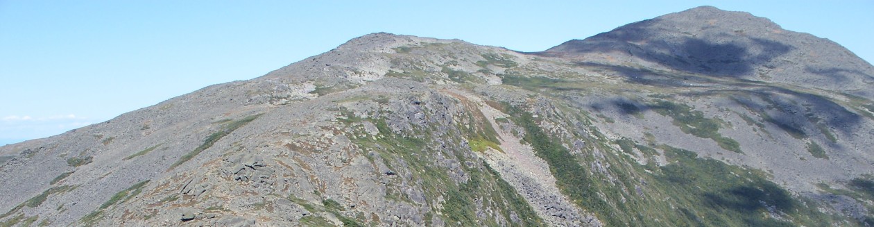
With all the rain, many of the springs were flowing fine, there seemed plenty of water, but there are stretches that are bone dry for miles, steep, endless ups and downs, rocky, bouldered, fallen logs, sharp rocks invisible under deep piles of wet leaves, steep steep down, oh my knees, my hip don’t fall don’t slip. No new rock faces on the AT in Virginia, all ancient stone covered in lichens and moss that have laid so for thousands of years. Up a hundred feet steep, down 200, up 60 feet, down 80 feet, grab the big high boulder, climb over the top of the knob, please, give us another knob, swing over the north side of the knob, gale force wind from the north, more rain coming sho’nuff, don’t slip and fall over the cliff. A sunny day, the clearest of blue skies, endless leaves crunching underfoot, bare branch hardwoods, long views, beautiful, rhododendron tunnels, beautiful, beautiful. Hard walking, steep.

In ’05, Woods’ Hole Hostel was a sweet oasis offered by octogenarian Tillie Woods, a gentile southern lady hostess who with her late husband Roy, had occupied a beautiful simple 100 acre farm with a small and magnificent chestnut log cabin that they lived in while Roy studied the resident elk population; the cabin fashioned in the 1880s with great skill using only axes and adze. Tillie has passed away, but her granddaughter Neville and her husband have taken over and carried on the tradition of hosting hikers, and Woods’ Hole is magnificent, better than ever, simple and pure, no wifi no tv, organic gardens, pure and quiet. In ’05, the use of cell phones was considered rude in the presence of others, it was hardly heard of around shelters, but today, everything is digitized, people yak and text, weather apps give up temperature and precipitation reports from shelter to shelter, most folks hiking with ear buds stuck in their heads, they hear nothing of nature, but they know exactly where pal Bozo is, when he left the shelter back behind and how many days or hours hiker Neon is ahead or behind the “bubble”. No guesswork here. No problem. Solar charger. No problem. Hey, no problem.
The Dragon’s Tooth, famous steep steep rock above Catawba, some iron bars embedded in the rock face to climb down (or up), hard for dogs to navigate. Somehow, Woodrose and I got separated coming down, where are you ?? I had Tyler, who is very athletic and capable, but who has trouble with narrow ledges and iron bars, and his backpack protruding could easily have thrown him off. We waited ten minutes…no Eva. where are you ? where the (expletive) are you ? How am I going to get this dog down off this rock ? where ARE YOU??? EVA!!!EVA!!! My voice echoing up and down through the rock, now I am scared, she must have fallen and hit her head. No reply. EVA!!!EVA EVA EVA!!! Two students from Virginia Tech, on a fast hike up the Dragon’s Tooth before class appear below me and I ask if they have seen her ?? They have not. Could you stick with me for a while, I think that she must have fallen and struck her head. I tie Tyler’s leash to a tree root, drop my pack and sprint in fear back up the rock to the crest and she is not anywhere. The students point out that they descended by another trail down through the rock, one less steep, and we decide that Eva must have done the same and that she is now below us. Tyler’s backpack has a handle on top like a suitcase and we pass him down the rock over the bars, soon, from way below, I hear her calling, James, where are you ?? (or something like that, I am fairly deaf, neither of us could tell what the other was shouting, but we knew each others’ voices. We were finally reunited and got down off the rock without bloodshed or loss of dog.
Va. 624 which we came to below the DT, led, in .4 miles, to a convenience store (Punjabi) that sold alcohol, so we ordered a pizza and bought some small cardboard containers of cheap wine and thought to proceed on, but at that moment, there appeared a battered van with dragons painted on its sides and a couple of hikers aboard, one of whom, Wayfarer, (my age)was well known and friendly with us, he had been coming over the mountain behind us and had heard all of the shouting, was glad to see that we were ok, and suggested that we come on back to the hostel with him in the van, the wine no problem, the hostel was alcohol and reefer tolerant, come and calm your shaken nerves.(we exchanged the small cardboard wine boxes for .750 liter bottles of 47 pound rooster).No problem. The hostel was well organized, offering shower and laundry, and was occupied by a number of hikers, most of whom were consuming alcohol and lounging about on various old cots, sofas, beds, and beater recliners that comprised the dozen or so sleeping locations in the three bay garage. Numerous chickens, two roosters, and a flock of guinea fowl milled about, Tyler was compelled to stay leashed. We pitched our tent outside way too close to the henhouse. Among the hikers was a group of four or so veterans of our endless wars in Iraq and Afghanistan. These boys were burnt, crippled with PTSD, some with weird tattoos in Urdu or Dari emblazoned on their skin. One of their number had recently committed suicide on McAffee Knob on the AT. He was an Army Ranger, a memorial to him with his likeness etched into a piece of black granite lay across a bench outside the hostel, the realization of what it meant , his young life wasted for WHAT? made me weep bitterly, veteran hiker soldier Short Cut hugged me close. Earl Shaffer was a WW2 combat veteran, the first person to thru-hike the AT, to “walk the war off his mind”. At least his war had a purpose, unlike the war that my brother died in, unlike the wars that these boys have sacrificed their lives for. For what?
None of this is important to anyone but the two of us and I’m getting tired of writing this, we are just a couple of old hiker trash, but our time spent backpacking is the best time we spend together after these more than 30 years together.Hiking makes us reliant upon one another in the most vivid and real sense, the closest of connections. Hold my hand. we hope we can hike some more this summer. We had plans to hike more than a 400 mile month, but the big rain and arthritis slowed us way down, we did 310 miles from Damascus to the James River at Glasgow. much harder, much steeper than the PCT or the CDT that we have hiked, much closer to civilization and resupply, but way harder on the knees than western trails that are mostly graded for pack animals.

All Best, from Poleworld, James M.S. (as in Mule Skinner) Johnson”
He certainly tells a good tale. Keep it up folks!